The drones looking inside explosively intensifying hurricanes

 Saildrone
Some tropical storms rapidly transform into a category five hurricane. Cutting-edge saildrones are helping to reveal how this process happens.
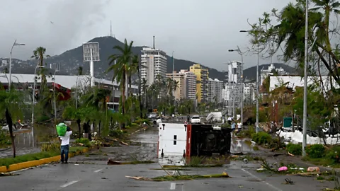
Hurricane Otis made landfall on the coast of southern Mexico on 25 October 2023 as a category five hurricane, battering towns and cities in its path with 165mph (270km/h) winds. At least 27 people were killed by Hurricane Otis, which caused widespread damage to buildings and power outages in Acapulco, a large port city and popular tourist destination, in the state of Guerrero.
The US National Oceanic and Atmospheric Administration (NOAA) described Otis as a "life-threatening storm surge" which would bring large and dangerous waves, destructive winds and heavy rainfall. This could lead to flash flooding and mudslides, NOAA warned.
"There are no hurricanes on record even close to this intensity for this part of Mexico," according to the National Hurricane Center.
Hurricane Beryl
On Friday 28 June 2024, Hurricane Beryl rapidly intensified from a tropical storm into a category four hurricane, moving towards the Windward Islands of the western Caribbean. The storm was then upgraded to a category five as it headed towards Jamaica, making it the earliest storm to reach that strength on record.
It is also being seen as an "alarming precident" for the coming Atlantic hurricane season. The 2024 Atlantic hurricane season is predicted to be extremely active, with four to seven major hurricanes expected, compared with an average of three.
See the hurricane's predicted path in Vanessa Buschschlüter's story for BBC News.
Forecasters said Otis "explosively intensified" by 110mph (177km/h) within 24 hours, rapidly morphing from a tropical storm into a category five hurricane. More storms like this are on the horizon as climate change causes hurricanes to intensify. The proportion of hurricanes that become category four and five is projected to increase due to climate change. Rising ocean temperatures are making storms transform rapidly into powerful hurricanes in a single day, according to a 2022 study by researchers at the University of Reading in the UK.
Now scientists are hoping to find out more about what leads these destructive storms to grow in intensity over such a short period of time.
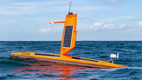
NOAA has partnered with US company Saildrone, a data company that manufactures seafaring drones, to deploy instruments capable of weathering the high winds and waves of developing hurricanes. These saildrones are packed with sensors to collect data about the oceanic and atmospheric conditions, which is then relayed to the government agency whose scientists will analyse the data.
A saildrone is a "wind-propelled vehicle that looks a lot like a sailboat", says Julia Paxton, director of mission management at Saildrone. The drones – which come in a variety of sizes, either 23ft (7m), 33ft (10m) or 65ft (20m) long – combine wind propulsion with solar-powered meteorological and oceanographic sensors that allow scientists to measure the track, or path, a hurricane it taking along with changes in its intensity over time.
The saildrones can also capture data beneath the waves and analyse ocean currents. This helps "create a complete [picture] of the air and water column, from 30,000ft (9,144m) above [sea level] to several 1,000ft (300m) below the surface", says Paxton.
Saildrone's mission is "not about predicting hurricanes this season", says Paxton. "It's about studying why and how hurricanes intensify so that in the future we can improve hurricane modelling."
Hurricanes form over warm water surfaces. As the ocean water evaporates and rises as warm air, it forms an area of low pressure underneath. This results in more air rushing in, which rises and cools and forms clouds and thunderstorms, which in turn release water droplets. This leads to the evaporation of even more water, fueling the storm. When wind speeds reach 74mph (119km/h) within such a storm, it is classified as a hurricane.
"The energy source for a hurricane is the transfer of heat from the ocean to the atmosphere," says Kerry Emanuel, professor emeritus in atmospheric science at the Massachusetts Institute of Technology (MIT).
"Before this project, there weren't any platforms that could measure the exchange of heat and momentum between the ocean and hurricanes, which could be steered into the path of a hurricane," says Greg Foltz, a NOAA scientist and one of the principal investigators of the mission.
More like this:
Armed with this data, scientists like Foltz hope to develop computer models that will allow them to more accurately predict where and with what force a hurricane may strike land. Intensity forecasts are critical as they help communities determine how to prepare and whether they should evacuate before the storm arrives, says Foltz.
"It's very costly to evacuate, to pick up millions of people and move them somewhere," he says. "It's not easy, the logistics of it. So you don't want to do it unless you're pretty sure that there's going to be a big impact."
CARBON COUNT
The emissions from travel it took to report this story were 0kg CO2. The digital emissions from this story are an estimated 1.2g to 3.6g CO2 per page view. Find out more about how we calculated this figure here.
Rapid intensification is when a storm intensifies by 35 knots of wind speed (40 mph or 65 km/h) or more within 24 hours, says Paxton. "When that happens right before landfall it is catastrophic, because the community is planning for a tropical storm, and they get [hit by a] category five hurricane," she says. It means they have very little warning of what is coming their way.
Hurricane Otis intensified very quickly, catching many meteorologists by surprise.
Rapid intensification also happened in the case of Hurricane Katrina, the costliest hurricane to ever hit the US, in 2005. "No one was warned. If you don't know the hurricane is coming in, you can't prepare for it." (Read more about what a record breaking hurricane looks like in this article by Lucy Sherriff.)
The saildrones can stay out at sea for long periods of time as they're wind-propelled. "The longest was just over a year, about 370 days, which is incredible," says Paxton. This is much longer than a crewed, fossil fuel-powered vessel could stay out at sea. "[The drones] are entirely dependent on renewable energy for propulsion and because of that they have this incredibly long endurance that vessels relying on fossil fuels can't match," she says.
 Getty Images
During the 2021 and 2022 Atlantic hurricane seasons, scientists deployed five and seven saildrones respectively in the western Atlantic Ocean. One of the drones in 2021 sailed through the eye wall of Hurricane Sam, a long-lived and powerful Cape Verde hurricane that reached the high end of category four intensity. It recorded video that revealed what it is like in the core of a major hurricane, with wind speeds just above the ocean surface of around 90mph (144km/h). In 2023, 12 saildrones were deployed in the western Atlantic, Caribbean and Gulf of Mexico to beam data back to weather prediction centres in real time.
While most of the data captured by saildrones is still being analysed, scientists say the technology is a critical tool in their efforts to better understand hurricanes.
"I'm extremely enthusiastic about the programme," says Emanuel. "It's often thought that with satellites and radars we have all the data we need…That's very far from the case."
While satellite images reveal where hurricanes are forming, they don't "necessarily [tell us] how strong they are", he says. "The saildrones, which are very inexpensive compared to satellites, are giving us that information, without risking human lives, and I think that's fantastic."
Additional reporting for this story was done by Jocelyn Timperley
* This article was originally published on 27 October 2023. It was updated to include details about Hurricane Beryl.
--
For essential climate news and hopeful developments to your inbox, sign up to the Future Earth newsletter, while The Essential List delivers a handpicked selection of features and insights twice a week.